
Getting Around
From the start, getting around was complicated because Durham had four settlements–South West Bend, East Durham, West Durham and South Durham. Communication was built up with neighboring towns before roads linked the four villages. Before the town began, in 1781, the River Road to what is now Auburn was laid out, and later in part moved west back over the hill. Another early road led to Harriseeket (now Freeport) for dragging trees to Mast Landing. Over time some roads were improved, others were abandoned and can barely be traced today. It took generations to turn blazed foot trails to ox-team ruts to horse and wagon roads, and at last to hard-surfaced streets and roads. Building and repairing these was a heavy burden for a poor community. Much of the work was done by residents, working off their taxes.
Even later, when railroads were laid out connecting towns with the outside world, trains would run along the east bank of the river (through Lisbon). In the days when trolleys rolled everywhere, they did not roll through Durham. Generally, townspeople have seemed to welcome being bypassed, able to keep to quiet ways.
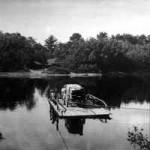
The Androscoggin River provided both a waterway to Lewiston and a barrier to towns east of the river. Ferries preceded bridges; Jones’s ferry served the eastern part of town for many years, run by Jeremiah Getchell. In 1818 two bridges were built, one at Lisbon Falls and one near the Bend. Both were swept away by freshets. Other ferries and bridges came and went; the last loss being the highway bridge to Lisbon Falls in the great flood of 1936 (since replaced).